CAD Studio - CAD/CAM/GIS/BIM/PLM solutions


")

After the successful add-on tools for Revit (Revit Tools) and Inventor (Inventor Tools), CAD Studio has developed a new add-on, this time for Civil3D 2013 users - Civil Tools.
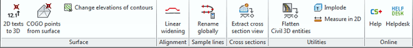
CAD Studio CivilTools enhance the CAD/BIM software product AutoCAD Civil 3D with a set of tools and automatic functions that will increase your productivity in Civil3D. Contains tools such as 2D texts to 3D, COGO from surface, contour elevations, converts cross section views to AutoCAD entities, flattens Civil 3D entities, etc.
The application Civil Tools is compatible with AutoCAD Civil 3D 2013 (32-bit and 64-bit, any language version). The trial version is limited for 15 days of using with no limitation in functionality.
 More information about this tool package (currently in English and Czech) is available on the Civil Tools page. Trial version can be downloaded and directly installed from the Autodesk Exchange Apps.

CAD Studio s.r.o. (an Arkance Systems company) is the leading Czech Autodesk Platinum artner (& Autodesk Top Dealer 1994-2020),
Autodesk Developer, Autodesk Consulting Partner + Training Center. More about CAD Studio.
CAD Studio provides systems - hardware, software, services - for CAD, GIS,
CAM, PLM, FM, animation and computer graphics. Our solutions are based on Autodesk technologies
- AutoCAD, Inventor, Revit, Map, Civil 3D, Plant 3D, Fusion 360, 3ds Max and other Autodesk products, plus our CAD services.
CAD Studio is an ADN member and developer of high quality
CAD, GIS and PDM applications - Revit Tools, Inventor X-Tools,
Civil Tools, VRMLout,
Excellink, DwgText,
CITin, SureSave,
LogOff,
DWGsync, JobTime,
LT Extension, etc...
You can use the ![]() icon to place your order online.
icon to place your order online.
We offer custom application development, training and software localization services. See our 3.000+ CAD Tips.

 CAD videos on YouTube
|
|


