CAD Studio - CAD/CAM/GIS/BIM/PLM solutions


")
|
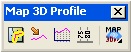
| Map3Dprofile toolbar |
Map3Dprof utility offers 4 commands:
Map3Dprof, PrfUnfold, PrfGraf and PrfDim
Just copy the MAP3DPROF.VLX file and the .MNS/.DLL toolbar files to one of your Autodesk Map support directories. Choose one of "autorun" methods (e.g. APPLOAD) to load it in your Map sessions or use MENULOAD Map3Dprof.mns to load its partial menu (toolbar).
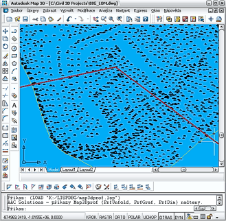 In an Autodesk Map 3D drawing with generated DTM surface (or
surfaces) draw a plan view profile (2D polyline representing
the profile geometry and position). This polyline should lay
(at least partially) in the area of the DMT surface; it can
contain multiple line segments (no arcs).
In an Autodesk Map 3D drawing with generated DTM surface (or
surfaces) draw a plan view profile (2D polyline representing
the profile geometry and position). This polyline should lay
(at least partially) in the area of the DMT surface; it can
contain multiple line segments (no arcs).
Start the Map3Dprof command, select the Surface by name or by
picking it (if there are more surfaces defined) a pick the 2D
polyline and enter the precision (distance between the adjacent
computed points). Map3Dprof generates a 3D profile (sitting on
the 3D surface) and prompts for unfolding of this profile (can
be also invoked later with the PrfUnfold command).
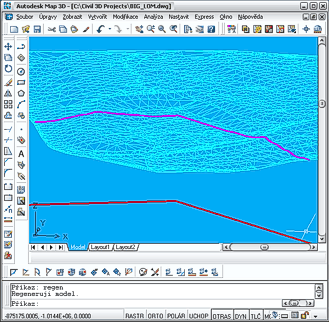 The unfolding process (PrfUnfold) converts the 3D profile into a 2D
representation (drawn in paperspace, the "Map3Dprof" layout)
of Distance-Height. You can define the height multiplication
factor, origin point for unfolding (in paperspace) - enter 0,0.
You can flip the orientation of the profile (watch the arrow)
and offset the unfolded profile from the origin of the 3D
profile. (you may want to delete or adjust the MVIEW in this
layout). Optionally you can export profile coordinates to a text file.
The unfolding process (PrfUnfold) converts the 3D profile into a 2D
representation (drawn in paperspace, the "Map3Dprof" layout)
of Distance-Height. You can define the height multiplication
factor, origin point for unfolding (in paperspace) - enter 0,0.
You can flip the orientation of the profile (watch the arrow)
and offset the unfolded profile from the origin of the 3D
profile. (you may want to delete or adjust the MVIEW in this
layout). Optionally you can export profile coordinates to a text file.
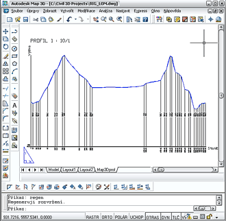 Then you are prompted to draw a graph (you can invoke it also
manually with the PrfGraf command). This function adds graph
legend to the unfolded profile. Select the unfolded (paperspace)
profile (or just confirm the "Last" option), enter the elevation
of the reference plane (in plain number, not including the height
factor), confirm the previously entered height factor and origin
(for cases when graph is drawn in another session), enter the
text size for labels (use a text style with variable height).
The "Do not draw redundand heights" option allow to skip height
lines which slope do not differ much from the neighbouring lines
- e.g. 5 degrees (or just enter 0 to draw all vertical lines).
Then you are prompted to draw a graph (you can invoke it also
manually with the PrfGraf command). This function adds graph
legend to the unfolded profile. Select the unfolded (paperspace)
profile (or just confirm the "Last" option), enter the elevation
of the reference plane (in plain number, not including the height
factor), confirm the previously entered height factor and origin
(for cases when graph is drawn in another session), enter the
text size for labels (use a text style with variable height).
The "Do not draw redundand heights" option allow to skip height
lines which slope do not differ much from the neighbouring lines
- e.g. 5 degrees (or just enter 0 to draw all vertical lines).
The RefDim function helps you to label the vertical height lines
with their height properties (use the offered PERP osnap to keep
the labels aligned horizontally).
| Version number | Description |
|---|---|
| 1.0 | First version (functionality based on GEOsurf 2.2) |
| 1.1 | Added profile coordinates export (to a text file) |
 Program was tested under Windows 2000 and Windows XP.
Program supports Autodesk Map 3D 2006 and Map 3D 2005.
Program was tested under Windows 2000 and Windows XP.
Program supports Autodesk Map 3D 2006 and Map 3D 2005.
Limited (number of vertices) trial version is free for download. If you are interested in the full unlimited commercial version, use the Order below or contact CAD Studio.
Price of the commercial version of Map3Dprof is 199,-EUR
![]() .
.
 Download limited free version of Map3Dprof (for Map 3D 2006 or Map 3D 2005)


