CAD Studio - CAD/CAM/GIS/BIM/PLM solutions


")
 CITin for AutoCAD

 CITin (V2023 - 5/2022) by CAD Studio is an add-on for AutoCAD 2019/2020/2021/2022/2023, 2016/2017/2018, 2013/2014/2015, 2010/2011/2012, 2007/2008/2009, AutoCAD 2004/2005/2006, AutoCAD 2000/2000i/2002 (or Map 3D or Civil 3D or AutoCAD Mechanical/Architecture or Raster Design or AutoCAD LT or even DWG TrueView) plus a separate version for Autodesk MapGuide and Envision.
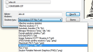
It allows to work with CIT files as easy as with other raster formats directly supported by AutoCAD. Any standard "IMAGE" and "IMAGEATTACH" commands can be used with such files.
CITin (V2023 - 5/2022) by CAD Studio is an add-on for AutoCAD 2019/2020/2021/2022/2023, 2016/2017/2018, 2013/2014/2015, 2010/2011/2012, 2007/2008/2009, AutoCAD 2004/2005/2006, AutoCAD 2000/2000i/2002 (or Map 3D or Civil 3D or AutoCAD Mechanical/Architecture or Raster Design or AutoCAD LT or even DWG TrueView) plus a separate version for Autodesk MapGuide and Envision.
It allows to work with CIT files as easy as with other raster formats directly supported by AutoCAD. Any standard "IMAGE" and "IMAGEATTACH" commands can be used with such files.
CITin add-on filter is distributed also with a standalone batch converter from CIT to TIFF format (incl. georeferencing).
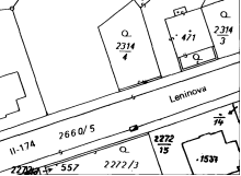
CIT is a widely used format in the MicroStation community. CIT is a special case of Intergraph Raster File Format (INGR) - a 1-bit version with CCITT G4 compression).
CITin requires AutoCAD 2000, 2000i, 2002, 2004, 2005, 2006, 2007, 2008, 2009, 2010, 2011, 2012, 2013, 2014, 2015, 2016, 2017, 2018, 2019, 2020, 2021, 2022, 2023 (or Map or Mech/Arch/LT) running on Windows 7/8/8.1/10/11, Vista, NT4/2000/XP or Windows 9x. Since version 2010, 32-bit and 64-bit versions of AutoCAD are supported. CITin for MapGuide (a separate product) supports Autodesk MapGuide R5, R6 and OnSite R6 plus Envision 8.
CITin just adds .CIT files to the options for reading (attaching) raster files (AutoCAD 2010/2011/2012, 2013/2014/2015, 2016/2017/2018, 2019/2020/2021/2022/2023 does not list individual formats). Georeferenced CIT files are supported in AutoCAD Map 3D, Land Desktop, Civil 3D and CAD Overlay, Raster Design (and Autodesk MapGuide).
Included in the commercial version of CITin are two standalone Windows aplications for batch conversion of .CIT files to the TIFF format. The CITtoTIFF.exe version is an interactive version with GUI, the CITincmd.exe version is for command scripts/batches.
CITin cannot process georeferencing data when CIT files are read from a R/O directory; slow processing of CIT files stored on network drives
| CITIN mail-list | ||
|---|---|---|
| Stay informed about the latest version of CITin - subscribe to CAD Studio software news mail-list. | ||
Shareware version is downloadable for free and can be copied for free - together with this README file. Shareware version is limited (half of the file is processed) and can be used only for evaluation purposes.
Price of the commercial version of CITin is 150,-EUR:
2023, 2022, 2021, 2020, 2019, 2018, 2017, 2016, 2015: ![]()
Price of the special version of "CITin for MapGuide" (+OnSite Desktop/Envision) is 390,-EUR.


