CAD Studio - CAD/CAM/GIS/BIM/PLM solutions


")
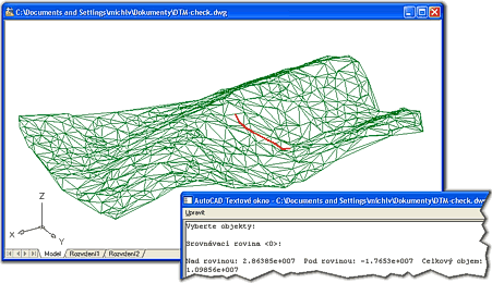
The DTM utility (command) for AutoCAD automatically creates an irregular triangular network (3DFACEs, 3DMESH) from a given selection set of 3D objects.
The DTM utility offers 8 commands: DTM, DTMVOL, DTMZ, DTMFLOW, DTMPPT, DTMMESH, DTMBORDER and DTMRND
|
| Digital terrain model and flowline generated by DTM |
Load the DTM utility (e.g. with the APPLOAD command) into your AutoCAD session (drawing) containing objects in 3D coordinates (block references/inserts, points, circles, shapes, texts, lines, or any other entities).
Just type the "DTM" command and select the source 3D objects. DTM will load the selected entities and generates a set of 3DFACEs (in the current layer). The optimization process can take up to several minutes.
Make sure your scene is near the global world origin (0,0) - otherwise the optimization arithmetics may not be precise (overlapping faces).
You can load 3D points from a TXT or XLS file into your AutoCAD session with utilities listed in CAD tips on www.cadforum.cz (see e.g. XLS2Curve).
The "DTMVOL" command computes the volume of your terrain model using the given reference plane, including the volume above and below this plane. Set the reference plane elevation according to the lowest point in your model.
The "DTMFLOW" command generated the flow-line on the surface of the model - it creates a watershed line (3D polyline) starting in the given point and going down to the lowest point on the model or going up to the highest point on the model (or both). Pick the starting point in the plan view. Set the step (precision) of the flowline.
The "DTMZ" command displays estimated elevations (Z-coordinates) of X-Y points (plan) picked in the area of the previously generated DTM model.
The "DTMRND" command generates a set of random 3D points in the selected area. The points form a terrain with a ridge and valley.
The auxiliar "DTMPPT" command extracts (creates) 3D points from vertices of polylines (LWPOLYLINE,3DPOLYLINE) - e.g. from (elevated) contour lines. Another option for using points from polylines for DTM is using the MEASURE command.
The auxiliar command "DTMMESH" (since DTM V1.3) requires AutoCAD 2010 (or higher). It converts the selected DTM-3DFaces to a single "3D Mesh" object. 3DMesh can be further processed with AutoCAD mesh commands - e.g. smoothed by MESHSMOOTHMORE. Other DTM commands no longer work on 3D meshes!
The command DTMBORDER (since DTM V1.4) draws a 3D polyline along the outer border (outline) of the selected 3DFACEs of the DTM model.
This DTM utility uses simplified optimization methods which may yield invalid
results in some situations. The maximum reasonable number of processed points
is about 2.000. Contours (isolines) are not generated.
For professional digital terrain models use e.g. AutoCAD Civil 3D.
| Version number | Description |
|---|---|
| 1.0 (11.1.2008) | First version (functionality based on GEOsurf 2.2) |
| 1.1 (13.1.2008) | Added command DTMPPT (polyline vertices extraction) |
| 1.3 (14.6.2009) | Added command DTMMESH - converts terrain model to AutoCAD 2010 3Dmesh
Filter objects for terrain model generator Extract points from 3D polyline |
| 1.4 (20.2.2018) | Added command DTMBORDER - draws outline polyline of the terrain model (M.Ribar) |
 Program was tested under Windows XP, Vista, Windows 7 and Windows 10.
Program supports AutoCAD 2018, 2017, 2016, 2015, 2014, 2013, 2012, 2011, 2010, 2009, 2008 and 2007 (may also support older versions).
Program was tested under Windows XP, Vista, Windows 7 and Windows 10.
Program supports AutoCAD 2018, 2017, 2016, 2015, 2014, 2013, 2012, 2011, 2010, 2009, 2008 and 2007 (may also support older versions).
DTM is a free utility originally written by Daniele Piazza, enhanced by CAD Studio. A limited support is provided for this freeware program in the discussion forum at www.cadforum.cz.
 Download the DTM application


