CAD Studio - CAD/CAM/GIS/BIM/PLM solutions


")
 CAD Studio - Civil Tools
See also Corridor Multiple Target - CMT
CAD Studio CivilTools enhances the CAD/BIM software product AutoCAD Civil 3D with a set of tools and automatic functions that will increase your productivity in Civil3D.
The application Civil Tools is compatible with AutoCAD Civil 3D 2019, 2018, 2017, 2016, 2015, 2014, 2013 (32-bit and 64-bit, any language version).
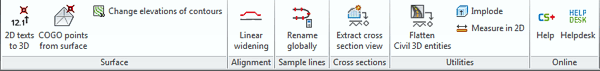
The command csct_txt2z converts selected texts with elevations (e.g. 125.36 or 125 36) to 3D points with true elevations (Z-coordinate) and also elevates the text to their respective elevation. You can use this tool to process old 2D drawings (DGN, DXF, DWG) from external sources and use them to generate digital terrain model in Civil 3D.
The command csct_SurfacePoints creates a group of COGO points from a selected surface. It helps when you need to create points in vertices (nodes) of a modified terrain. This tool lets you select a surface in Civil 3D and generates its special group of COGO points - then you can export it to a text file.
The command csct_chelev assigns elevations to a series of polylines or lines. You can use it to convert a set of 2D contours to 3D. After you set the initial elevation and the contour interval, it moves the "fence"-selected countour lines or polylines to their respective elevations (Z-coordinates).
The command csct_rozsireni generates a parametric widening (offset) along an existing alignment in AutoCAD Civil 3D projects.
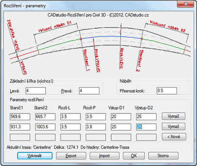
Depending on the setting of the CMDDIA variable, the dialog- or commandline-based version of the function is launched. After you select the alignment axis you can enter the parameters for edges and offsets (initial offset left/right, taper precision). The command supports multiple, non-overlapping widening segments, with the parameters:
The requested segment data can be entered interactively (by picking in the drawing), or numerically (entering the values via your keyboard). You can edit the data in the application dialog. The number of segments is not limited
The generated alignment edges are polyline objects placed in the layer of the original alignment. You can subsequently convert them e.g. to Feature lines (the command CreateFeatureLines).
The entered parameters are stored in the alignment object so they can be reused when using this command in future sessions. You can also import and export the alignment parameters from/to a CSV text file (Excel). You can also use Excel (or your text editor) to do batch editing of the parameters. You will be notified (reactor) when the alignment needs an update.
The command CSCT_SHOWALIGMENTSLOPE ...
...
...
The command csct_sprx renames selected sample lines or the whole sample line group in an increasing or decreasing order or with an optional prefix. This command is handy e.g. for renumbering of cross sections in river modelling projects, or for creating points along a railway track alignment.
The command csct_explode_sectionview converts selected cross section views to simple AutoCAD entities. After the extraction, the entities are stored in a new, empty drawing -- you can specify its DWT template (does not carry over all unneccessary styles). If you change corridor parameters, Civil 3D automatically redraws all cross section views, but if the change affects only a single view, you can use this tool to effectively exchange the new cross section view and the old one on your final drawing. You can also use this for mirroring of cross section views for hydrology projects (down-flow, up-flow).
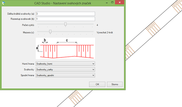
The command csct_SlopePatternCreate prompts to select two 2D polylines and displays a dialog for definition of slope patterns (marks). Here you can set pattern parameters (short slope marks, offset, spacing, cycles and layers). The command then generates slope marks dynamically linked to defining 2D polylines. If you change geometry of these curves, the slope pattern is updated automatically. You can also change the parameters of existing slope patterns with the csct_SlopePatternModify command.
The command csct_SlopePatternErase removes the pattern (keeping the definining polylines). To be able to share the drawing with users without Civil Tools 2016, you can explode slope patterns to standard lines using the csct_SlopePatternExplode command.
The command csct_convert_to2D converts Civil objects, such as Surface, COGO Points, Corridor, Grading and FeatureLine to 2D. During the conversion, 3D corridor feature lines are changed to convenient "joined" curves. Object layers are added to the project.
The commands csct_implode simply converts selected objects to a block with a reference point.
The command csct_hordist lists a distance of two specified points in the 2D plan projection and simplifies standard measuring in a 3D elevated drawing.
Online tools provide access to web resources for the users of AutoCAD Civil 3D and Civil Tools - to the application homepage on the CAD Studio web site.
The Civil Tools functionality is rapidly enhanced. You can send us proposals of other functions that will make your work in Civil3D more effective.
The Trial version is time-limited (15 days) and has limited functionality (some advanced functions missing).
If you are interested in the commercial version of CADstudio Civil Tools, use the BUY icon below or contact CAD Studio.
Price of the commercial version of Civil Tools see -
![]() (for Civil 2013-2016)
(for Civil 2013-2016)
Czech customers can order through this link - ![]() .
.
 Trial version of CADstudio Civil Tools can be downloaded from Download (for Civil 2013-2016) or from the Autodesk Revit Apps store


